British Coast Maps
Coastal Maps of Britain
 

home

map index

sitemap


The British Coast in Maps

Maps of the entire coastline of Great Britain from Shetland to Land's End

I hope that this website will be of interest, and some use, to those who like to be beside the seaside, on or even simply near the British coast, in all its great variety, from the fjord-like sea lochs of the north west Scottish highlands to the low marshes and fens of the south east of England, from the sandy coves of Cornwall to the red sandstone cliffs of the Scottish east coast, from the industrial docklands of London to the weedy shores of the Solway Firth, from the rocky limestone lochs of Durness to the chalky white cliffs of Dover, from the wild Atlantic Ocean in the west to the North Sea in the east. With a click of the mouse, this site provides easily accessed large scale maps of the entire coastline of Great Britain. The maps are derived from the Bartholomew half inch series of the last century and cover the whole of Great Britain. It is unfortunate that this map series covered only Scotland, England and Wales and not Ireland, so the maps must be limited to Great Britain and the Scottish Islands.

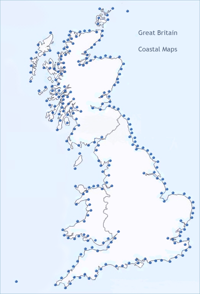
Maps of the Coastline of Great Britain

click on a blue dot to view a map of that section of the British coast

Cape Wrath Kinlochbervie Rhiconich Scourie Unapool Stoer Lochinver Achiltibuie Ullapool Gruinard Loch Ewe Poolewe Gairloch North Lewis West Lewis Stornoway South Lewis Harris North Uist Benbecula South Uist Barra North Skye Central Skye Rassay East Skye Torridon Applecross Lochcarron Lochalsh Glenelg Mallaig Arisaig Ardnamurchan Coll Tiree Tobermory Sound of Mull Morvern Fort William Loch Linnhe Iona East Mull Glen Etive Loch Etive Oban Lochmelfort Kilmartin Lochgilphead Glen Fyne Loch Fyne Knappdale Loch Sween Colonsay Jura North Islay South Islay Kintyre Mull of Kintyre Bute Arran Loch Long Dumbarton Glasgow Greenock Irvine Ayr Girvan Ballantrae Stranraer Mull of Galloway Wigtown Kirkcudbright Dumfries Solway Solway Firth Cumbria Eskdale Morecambe Bay Lake District Lancaster Blackpool Liverpool Lytham Mersey Flint Rhyl Colwyn Bay Bangor Llandudno Isle of Man north Isle of Man south Anglesey North West Wales Caernarvon Portmadoc Barmouth Machynlleth Aberystwyth Aberayron Cardigan Fishguard Milford Haven Pembroke Tenby Carmarthen Llanelli Kidwelli Swansea Bridgend Cardiff Newport Severn Bristol Clevedon Weston Super Mare Minehead Ilfracombe Bideford Bude North Cornwall St Ives Newquay Bristol Channel Land's End Lizard Point Falmouth Megavissey Plymouth Fowey South Devon Torquay Teignmouth Exeter Sidmouth Bridport Poole Bournemouth Isle of Wight Southampton Portsmouth Chichester Worthing Brighton Eastbourne Hastings Dungeness Dover Deal Kent Margate Whitstable River Medway Thames Estuary River Thames Southend Maldon Clacton Harwich Ipswich Aldeburgh Southwold Lowestoft Yarmouth Norfolk Cromer Wells King's Lynn Boston Skegness Lincolnshire Lincoln Hull Goole Hornsea Bridlington Filey Scarborough Whitby Redcar Middlesbrough Hartlepool Peterlee Seaham Sunderland Newcastle Blyth Newbiggin Alnmouth Bamburgh Berwick Eyemouth Dunbar Northberwick Edinburgh River Forth Fife Coast Fife St Andrews Firth of Tay Dundee Arbroath Montrose Inverbervie Stonehaven Aberdeen Newburgh Peterhead Fraserburgh Banff Spey Bay Lossiemouth Findhorn Moray Firth Cullen Inverness Beauly Firth Dingwall Cromarty Firth Dornoch Firth Brora Helmsdale Caithness Tain Clyth Ness Wick Thurso Melvich Strathy Point Tongue Loch Eriboll Hoy, Orkney Stronsay, Orkney Orkney, east mainland Orkney, West Mainland Westray, Orkney Sanday, Orkney Shetland Islands Grimsby Western Skye Scilly Isles

The maps on this website have been reproduced with the permission of Collins Bartholomew

In the half century since the maps were made, some coastal areas will have undergone changes, a new bridge or road perhaps, the expansion of the residential districts of our seaside resorts or the decline of the industrial areas associated with our great seaports, developments which may not show on these maps. For the most part, however, not a lot will have changed and the maps will reflect the essential character of the long coastline of Great Britain, the mainland alone estimated at around 11,073 miles or 17,820 km, in all its splendid variety.  If we include the principal island groups of England, Wales and Scotland, the coastal length increases to around 19,491 miles or 31,368 km. All the maps of the British coast may be accessed simply by clicking on a blue dot on the map below or by selecting a coastal place name from the coastal map index.

LONDON MAPS

view detailed street maps of twentieth century London


  Links

The British Coast

privacy